


Digital News Guru Current Affairs Desk:
A Landmark Launch: NASA‑ISRO NISAR Takes Flight
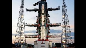
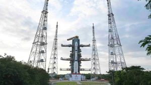
On July 30, 2025, the world’s most advanced Earth observation satellite, NISAR (NASA‑ISRO Synthetic Aperture Radar), is set to lift off aboard ISRO’s GSLV‑F16 at 5:40 PM IST from the Satish Dhawan Space Centre in Sriharikota.
Weighing approximately 2,392 kg and valued at around $1.5 billion, NISAR represents a decade-long collaboration between the Indian Space Research Organisation (ISRO) and NASA’s Jet Propulsion Laboratory—a mission destined to redefine Earth observation technology.
Dual‑Frequency Radar: Seeing Through Everything
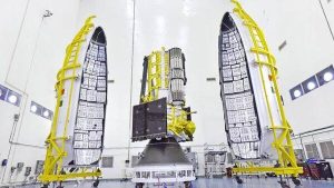
NISAR is the first satellite to deploy dual-frequency synthetic aperture radar, pairing NASA’s L‑band and ISRO’s S‑band sensors. It carries a deployable 12‑metre unfurlable mesh antenna, enabling radar imaging at 5–10 m resolution across a 242 km swath width—regardless of weather or daylight.
This powerful imaging capability allows NISAR to penetrate clouds, vegetation, soil, and ice, monitoring changes as small as a few centimetres on the Earth’s surface.
Mission Profile & Commissioning Timeline
After launch, GSLV‑F16 will insert NISAR into a sun‑synchronous orbit at approximately 743 km altitude, inclined at ~98.4°—ensuring it passes over the same location under consistent lighting conditions each day.
Over the next 10–18 days, the satellite will perform crucial deployment operations—including spinner activation, solar panel extension, and antenna unfurling and calibration.
Following this, the mission enters a ~90‑day commissioning phase, during which onboard systems are validated, sensors tested, and downlink operations finalized. Only after this stage will scientific operations officially begin—launch marks the beginning of the mission, but true data gathering comes later.
The primary mission will last a minimum of three years, with consumables to support up to five years of operations.
Global Intelligence: What NISAR Will Track
Once operational, NISAR will scan nearly all land and ice surfaces every 12 days, delivering critical datasets every 6 days on average from its ascending and descending passes.
Key applications include:
- Tectonic and geological monitoring: Tracking ground deformation from earthquakes, volcanic uplift, subsidence.
- Cryospheric dynamics: Capturing glacier movements, ice-sheet shifts, sea‑ice classification.
- Hydrology and agriculture: Mapping soil moisture, wetland dynamics, surface water resources, crop health, irrigation planning.
- Disaster management: Enhancing responses to landslides, floods, storm surges, hurricanes, tsunamis.
- Ecosystem and vegetation: Observing forest cover change, biomass estimation, wetlands and coastal shoreline monitoring.
All mission data will be shared freely with the global science community, democratizing access to real-time environmental intelligence.
A New Era in Scientific Diplomacy
NISAR is a hallmark of Indo–US scientific cooperation, representing over ten years of joint development. It builds on precedent-setting collaborations such as the 1970s SITE (Satellite Instructional Television Experiment)—but in Earth observation, missions of this scale are rare.
Dr. Jitendra Singh, India’s Minister of Science & Technology, described NISAR as “India’s scientific handshake with the world,” positioning it as a global benchmark for international collaboration leading actionable climate data to support vulnerable communities.
Watch It Live: Viewing the Launch Online
NASA will provide live coverage of launch activities, starting at 8:10 a.m. EDT (5:40 p.m. IST), on NASA+, YouTube, and affiliated social media platforms. ISRO may also stream the event through its official channels and social handles.
Why NISAR Matters
- Technological first: Dual-frequency SAR, deployable mesh antenna, large swath imaging under all conditions.
- Science impact: Continuous, high-precision Earth surface mapping to monitor changes to within centimetres.
- Global utility: Data streams support climate research, disaster management, agriculture, water resource planning, and urban resilience.
- Humanitarian diplomacy: Projects rooted in international cooperation that provide open science for global good.
- Capacity building: Inspires a generation of researchers and strengthens institutional collaboration between NASA and ISRO.
Summary Table
| Feature | Summary |
| Launch | July 30, 2025, 17:40 IST / 8:10 a.m. EDT |
| Launch Vehicle | ISRO GSLV‑F16 |
| Launch Site | Satish Dhawan Space Centre, Sriharikota |
| Mass & Cost | ~2,392 kg; ~$1.5 billion |
| Orbital Parameters | ~743 km sun-synchronous, ~98.4° inclination |
| Radar Payload | NASA L‑band, ISRO S‑band; 12 m reflector |
| Data Coverage | Global, scans every 12 days; 6‑day revisit |
| Mission Duration | 3–5 years |
Looking Forward
As NISAR embarks on its orbital journey, its true legacy will unfold in the months to come, as it transitions into full operational mode. From mapping shifting glaciers to forecasting floods, and enabling smarter agricultural decisions, its radar eyes will look beyond politicians and borders—beaming down the future of Earth science.
Stay tuned after launch—you may like updates on initial images, data access portals, or mission dashboards as they go live. For now, all eyes are on 5:40 PM IST, when NISAR finally lifts off.
You May Also Read: Animated Epic Mahavatar Narsimha Earns Rs 21.85 Cr in India


")
