


Digital News Guru National Desk:
Monsoon Makes a Grand Entry: Sweeps India 9 Days Early
On June 29, 2025, India’s southwest monsoon completed its annual journey, covering the entire country 9 days ahead of the typical July 8 date, according to the India Meteorological Department (IMD). Making it the earliest nationwide coverage since 2020, this early arrival has profound implications for agriculture, the economy, and disaster preparedness. Here’s an in-depth look at how this unfolded, what fueled it, and what lies ahead.
Quick Spread: From Kerala to Kashmir
- Kerala Heralds the Arrival
The monsoon hit Kerala on May 24, a staggering eight days earlier than its usual June 1 onset—the earliest since 2009. This early burst over southern India set the stage for a faster-than-usual spread. - Rapid Cascade Northward
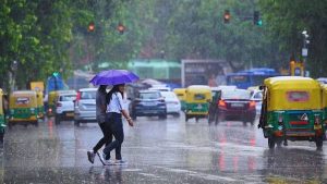
Following Kerala, heavy rainfall reached Mumbai by May 26, marking its earliest arrival in 25 years. Early June saw a brief lull, but renewed cyclonic activity from the Bay of Bengal and Arabian Sea invigorated the system. - All-India Coverage by June 29
By June 29, monsoon rains had swept through northern regions including Delhi, Punjab, and Rajasthan, achieving total national coverage nine days early—the fastest since 2020 when full coverage occurred by June 26.
Agricultural Windfall: Early Sowing & Water Recharge
The monsoon’s lifeblood largely sustains India’s $4 trillion economy, supporting around 70% of annual rainfall. Nearly 50% of farmlands rely on these rains for kharif sowing of crops like rice, soybeans, sugarcane, corn, and cotton.
- The early onset accelerates kharif planting, giving farmers crucial lead time for robust yields.
- It recharges groundwater tables ahead of schedule, alleviating water stress in non-irrigated regions.
- With the IMD forecasting 106% of long-period average rainfall for June–September, this continuity promises a second consecutive above-normal monsoon.
Economists note that timely, abundant monsoon rains help curb inflation by stabilizing food prices and enhance export potential, especially of staples like rice.
Regional Impacts & Safety Alerts
The fast-moving monsoon hasn’t been uniformly benevolent—some regions are now on high alert:
- Jharkhand: Issued a red alert for extremely heavy rainfall in four districts and orange alerts in nine, as total rainfall crossed 327 mm—well over the usual 181 mm for June.
- Uttarakhand: Witnessed severe monsoon impacts with 65 deaths in June—double last year’s toll—due to cloudbursts, landslides, and pilgrim accidents.
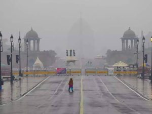
- Delhi–NCR: Received welcome relief from heat, though official monsoon declaration by IMD is gradual. Scattered showers cooled temperatures by up to 12 °C .
Overall, the reach of the monsoon has diversified disaster response priorities—from agricultural gains to urgent flood mitigation efforts in vulnerable zones.
Why the Early Arrival?
Scientific analysis points to several key drivers:
- A Strong Madden‑Julian Oscillation (MJO)
Active MJO phases boosted convection over the Indian Ocean in late May, accelerating monsoon onset. - Favorable Wind Patterns & Low‑Pressure Systems
Bay of Bengal and Arabian Sea circulation accelerated northward monsoon movement, even overcoming earlier dry conditions in early June. - Jet Stream Positioning
A northward shift in the subtropical westerly jet helped trigger the “bursting” phase of the monsoon, pulling rains inland. Better land–sea thermal gradients likely enhanced moisture-laden airflow across the subcontinent.
Together, these forces resulted in one of the fastest monsoon advances since systematic record-keeping began in the 1960s.
Historical Context: A Rare Phenomenon
- Since 1960, a full June coverage has been recorded only 10 times, including years like 1961, 2013, 2015, 2020—and now 2025.
- June’s revival from a 31% rainfall deficit to finishing with a 9% surplus underscores the sheer momentum of the current monsoon surge.
While an early monsoon may initially raise flood concerns, it benefits economic planning and resource management—compared to delayed or erratic arrivals.
What Lies Ahead
Rainfall Distribution & Flood Risks
IMD expects that rain will intensify in central, eastern, and northern regions, with lingering episodes in the Bay of Bengal and Arabian Sea belt. His fallback could involve localized flooding and landslides, prompting safety advisories.
Agricultural Preparedness
Farmers should capitalize on the moisture window—begun kharif sowing immediately. But they must also heed crop care advisories to avoid waterlogging and fungal disease.
Disaster Management Readiness
States like Jharkhand, Uttarakhand, Himachal Pradesh, and parts of Western Ghats are beefing up emergency infrastructure, warning systems, and evacuation protocols for vulnerable populations.
Economic and Hydrological Outlook
If the 106% rainfall forecast materializes, the monsoon could suppress food inflation, boost rural incomes, and stabilize reservoir levels—critical for industrial and irrigation usage .
Summarizing the Significance
The June 29, 2025, completion of India’s monsoon coverage marks a dramatic and beneficial shift in weather patterns:
- It injects a buoyancy into kharif agriculture and rural livelihoods.
- It recharges groundwater and improves drought resilience.
- It calls for heightened alertness to flood risk in sensitive regions.

This early monsoon could serve as a watershed moment—not only for the sowing season but also for long-term water security and climate resilience.
Bottom Line
- West-to-north monsoon surge by June 29, 2025: earliest since 2020.
- Agricultural boost: early sowing and better water availability.
- Risks: flash floods, landslides in Jharkhand, Uttarakhand, and other hilly zones.
- Outlook: sustained, above-normal rains could catalyze economic uplift—but require proactive disaster management
You May Also Read: North Waziristan Suicide Bombing: MEA rejects Pakistan Army claim blaming India, says “Deserves contempt”


")
